Explore the varied terrains and political outlines of North America with topographic and reference wall maps. This guide highlights five highly rated options that blend detailed relief, clear borders, and durable finishes for classrooms, offices, or homes. Each pick offers different scales, laminations, and presentation styles to suit learning, planning, or decoration needs.
| Product | Brand | Format | Size |
|---|---|---|---|
| Muir Way North America 1965 Shaded Relief Map | Muir Way | Shaded Relief Print | 24″ x 32″ |
| Maps International Large Political North America Wall Map | Maps International | Laminated Poster | 48″ x 36″ |
| North America Wall Map – Atlas of Canada Laminated | MapSherpa | Laminated | 34″ x 39″ |
| North America Wall Map – Atlas of Canada Paper | MapSherpa | Paper | 34″ x 39″ |
| National Geographic Maps: North America Political Wall Map – Compact | National Geographic | Laminated | 21.5″ x 16.25″ |
Note: Each product emphasizes different aspects, from shaded relief topography to political boundaries, making it easy to tailor your choice to educational use, travel decor, or professional planning.
Muir Way North America 1965 Shaded Relief Map

This print presents a vintage-inspired shaded relief view of North America, blending modern elevation data with classic cartographic style. It emphasizes terrain features such as peaks, valleys, and plateaus to create a three-dimensional impression on flat paper. Suitable as wall art or a focal point in a study or cabin, the design is ready to frame and complements educational displays or gift collections for outdoors enthusiasts.
Maps International Large Political North America Wall Map

This large, laminated political map highlights country boundaries, major towns, and cities, with a finalized encapsulation finish that protects the poster. The lamination allows dry erase or marker use, making it a practical tool for classrooms or home offices. Its 48 by 36 inches provides a substantial display area for classroom activities, travel planning, and regional studies.
North America Wall Map – Atlas of Canada Laminated
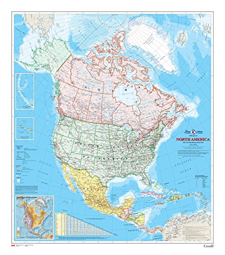
This laminated wall map from MapSherpa presents North America with a clear 1:10,000,000 scale. It highlights populated places, transportation routes, and drainage networks, with insets covering Alaska, Hawaii, and major relief. The lamination adds durability and ease of cleaning, making it suitable for classrooms, offices, or living spaces that require frequent use and writing.
North America Wall Map – Atlas of Canada Paper
Printed on paper and delivered tubed for shipping, this MapSherpa atlas-style map provides the same scale and cartographic detail as its laminated counterpart without the gloss finish. It is ideal for educational settings where students need to reference country boundaries and major infrastructure without the reflective surface of lamination.
National Geographic North America Political Wall Map – Compact

National Geographic’s compact political wall map features a glossy laminated finish designed for durability and repeated writing with dry erase markers. The compact size (21.5 x 16.25 inches) makes it suitable for smaller spaces, personal desks, or classroom sidewalls, while remaining legible for quick reference and planning sessions. The lamination helps resist wear and tearing while keeping colors vibrant.
Buying Guide: Key Purchase Considerations
- Purpose and setting: Decide whether you want a topo-style relief, political boundaries, or a mix. For classrooms and travel planning, laminated options with markers are practical; for decor, a shaded relief art-style map can serve as a focal piece.
- Scale and detail: Larger maps (e.g., 48″ x 36″) show more towns and routes but require more wall space. Smaller formats are easier to integrate into tight spaces.
- Finish and durability: Lamination protects against wear and cleaning but may reflect light. Unlaminated or paper maps are cheaper but require framing or protection behind glass.
- Insets and supplementary data: Maps with inset regions (Alaska, Hawaii) or road mileages provide richer context for navigation and education.
- Color and readability: High-contrast colors improve legibility from a distance, especially in bright rooms or classrooms with overhead lighting.
- Content accuracy: Geographic accuracy matters in educational contexts. Reputable brands like National Geographic and MapSherpa tend to emphasize reliable cartography.
- Mounting and framing: Consider whether you’ll frame the map, mount it with a corkboard backing, or use adhesive strips for quick changes in a living or teaching space.
- Budget and space: Larger laminated maps cost more but last longer in high-use areas. Balance cost against expected usage and wall space.
Across these options, decisions hinge on whether your priority is topographic shading, durable write-on surfaces, or decorative appeal. The selections above cover a spectrum from artful relief maps to practical, classroom-ready tools, helping you choose a North America map that matches your environment and goals.