Exploring world geography through engaging maps helps students understand continents, countries, capitals, and global relationships. This article highlights five curated world map products ideal for classrooms, homeschooling, and self-guided study. Each option focuses on durability, clarity, and educational value, making it easier to teach or learn geography effectively.
Summary table of chosen products:
| Product | Brand | Size | Lamination / Material |
|---|---|---|---|
| Laminated World Map & US Map Poster Set | Palace Learning | 18″ x 29″ | 3 mil lamination, laminated |
| 2 Pack World Map Poster & USA Map Chart | Palace Learning | 18″ x 29″ each | 3 mil lamination, laminated |
| World & USA Map Set (3D/laminated) | Swiftmaps | 24″ x 36″ | Laminated |
| Large World Map With Flags & Capitals | The World Game | 26″ x 38″ | Poster, durable paper |
| US And World Desk Map (Laminated) | Lighthouse Geographics | 13″ x 18″ | Two-sided laminated |
Laminated World Map And Us Map Poster Set

This Palace Learning set includes an 18″ x 29″ world map and a US map, both laminated for durability in high-traffic spaces like classrooms. The updated posters provide clear delineations of borders, labels, and country names. The single-wide format makes it easy to mount on walls or classroom boards, creating a quick geography reference for students of all ages.
Educational value lies in its readability and practical durability. The 3 MIL lamination protects against spills and handling, extending the poster’s life in teaching environments. It serves as an accessible visual anchor for lessons on continents, oceans, and national borders, supporting a wide range of activities—from map-labeling exercises to geography quizzes.
2 Pack World Map Poster & USA Map Chart

This option provides a value-packed set of two posters, each 18″ x 29″ and laminated for durability. The tan/color design offers a classic look that blends well with various classroom decors. Teachers gain easy-to-read country labels, capital names, and geographic boundaries, enabling quick reference during lessons on world regions, map skills, and global awareness.
With dual posters, teachers can pair complementary activities—for instance, a world-travel planning exercise alongside a country-capital matching task. The laminated surface supports writing with dry-erase markers for quick in-class assessments and interactive learning sessions.
Evan-Moor The World Reference & Map Forms

The World Reference & Map Forms from Evan-Moor is a structured resource that pairs a world map with US boundaries. It includes detailed references to countries, areas, populations, and elevations, plus fun facts about continents. This title emphasizes teacher support pages, reproducible student pages, and an answer key, making it a strong choice for guided lessons, worksheets, and assessment preparation, especially in curricula that emphasize map literacy and data interpretation.
Parth iMPEX Large World Map Poster Tapestry

This large fabric wall map (36″ x 56″) doubles as a tapestry and wall hanging suitable for classrooms or travel-themed rooms. Its machine-washable design and bright, high-definition printing preserve color integrity over time. The ready-to-hang tapestry offers versatility in decor styles—from Bohemian to minimalist—while supporting geography lessons with a vivid display of world political boundaries and clear labeling. It’s ideal for large-group instruction and visual storytelling about continents, countries, and capitals.
24×36 World And USA Classic Premier 3D Two Wall Map Set

This two-map set from Swiftmaps features large, laminated educational posters with 3D terrain relief. The 24″ x 36″ dimensions provide a detailed view of global geography and US geography. Laminated surfaces support dry-erase use, enabling interactive lessons such as map-reading practice, label placement, and in-depth comparison of political boundaries versus physical terrain. Colors are designed to stay vibrant, making it a long-lasting classroom staple.
Large World Map With Flags & Capitals
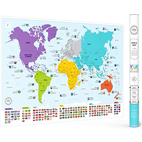
The World Game’s large world map focuses on accessible content for kids and adults alike. It features flags and capitals, with color-coded continents to simplify learning. This poster supports classroom decor and homeschooling setups by providing an easy reference for countries, capitals, and regional groupings. The 26″ x 38″ size balances visibility with wall space, making it suitable for a variety of room layouts and teaching contexts.
US And World Desk Map (Laminated)
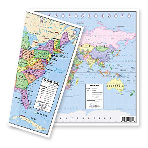
This two-sided laminated desk map from Lighthouse Geographics provides a compact yet comprehensive geography tool. One side shows the United States in pastel colors with state details, time zones, and capitals. The other side presents a world map with current geographical information. The inserts for Alaska and Hawaii extend the US coverage, making it a practical option for desks, small groups, and home study spaces where space is at a premium but educational value remains high.
Buying Guide
- Quality and durability: Look for laminated surfaces or fabric tapestries that resist wear and allow dry-erase use for activities and quick checks. A sturdy mounting option helps ensure long-term classroom visibility.
- Size considerations: Choose sizes that fit your space and teaching style. Large maps work well for whole-class instruction; smaller desk maps support individual study or desk corners.
- Content coverage: Ensure the map includes countries, capitals, time zones, and relevant political boundaries. Some resources add flags, elevation data, or interesting facts to deepen engagement.
- Two-sided and multi-map options: Two-sided desk maps or sets with multiple posters enable varied activities, such as comparing US and world geography or practicing map-reading skills.
- Educational support: Teacher guides, reproducible student pages, and answer keys can streamline lesson planning and assessment, especially for structured curricula.
- Decor and theme compatibility: Consider color schemes, border styles, and overall aesthetic to match classroom design, homeschool spaces, or study rooms for improved engagement.
- Budget and value: Sets that include multiple posters offer more learning value per dollar, especially for classrooms or group study setups where several learners benefit from the same resources.
Overall, the selected products provide a balanced mix of durability, readability, and educational depth. They enable a range of activities—from label placement and map-reading drills to flag recognition and capitals quizzes—supporting comprehensive social studies and geography instruction across different learning environments.